our company services and products careers partner with us client support contact us
Focus on Your Real Job
Over the past 15 years, collecting forestry information and producing operational maps while maintaining spatial data integrity required both a GIS specialist and a forest professional. Today’s business challenges require GIS specialists to concentrate on analytical activities and forest professionals to have desktop access to spatial data information for carrying on their work. Through this transition period from the paper to the digital world, many GIS specialists and forest professionals lost focus of their real jobs!
Core Mapping Information System (CoreMIS) is the first powerful commercial desktop mapping application developed for forest professionals by forest professionals. Built on the Microsoft Windows platform, CoreMIS takes the power of today’s computers and spatial technologies to streamline and automate information collection and management processes. Using CoreMIS, organizations can reduce operational costs, simplify data administration and empower their resource professionals with desktop abilities and focus on their real jobs!!
For non-technical users, CoreMIS is a cost-saving application that allows them to have complete control over map production and enjoy generating a variety of standard maps without going back and forth with a technical GIS expert. For GIS specialists, CoreMIS increases operational efficiency by freeing them from managing daily mapping activities and allowing them to focus on performing tactical planning (e.g. FSP) and advanced strategic analysis (e.g. Timber Supply Analysis). The result is a phenomenal testament to productivity!
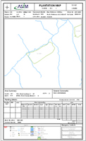
click on the map to see details
Released in November 2005, CoreMIS 5.0 for ArcGIS marked a milestone for ASIM and represents our continued effort to provide you with quality products and services. CoreMIS 5.0 brings to new heights the value you derive from your spatial data by allowing you to perform numerous forestry operational tasks quickly and effortlessly. Visit the key features section of our site for description of key functionalities and benefits of CoreMIS.
 CoreMIS 5.0 for ArcGIS
Get Back to the Woods
product overview
key features
modules and plug-ins
system requirements
faq
what’s new!
what they say…
ASIM is a proud partner of:

our company | services and products | careers | partner with us | client support | contact us